
Topografische kaart Highland State Recreation Area
Interactieve kaart
Klik op de kaart om de hoogte weer te geven.
Highland State Recreation Area
West of Duck Lake Road in Highland State Recreation Area, a group of small moraines are locally called "mountains"—the highest elevation in the park, Mount Kanzer, is 1,150 feet (350 m) above sea level. The highland for which this recreation area is named is this group of moraines.
Over deze kaart
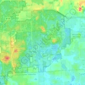
Naam: Topografische kaart Highland State Recreation Area, hoogte, reliëf.
Gemiddelde hoogte: 302 m
Minimale hoogte: 282 m
Maximale hoogte: 355 m