
Topografische kaart Cottondale
Interactieve kaart
Klik op de kaart om de hoogte weer te geven.
Over deze kaart
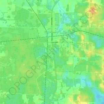
Naam: Topografische kaart Cottondale, hoogte, reliëf.
Locatie: Cottondale, Jackson County, Florida, United States (30.76290 -85.39030 30.81198 -85.33041)
Gemiddelde hoogte: 45 m
Minimale hoogte: 29 m
Maximale hoogte: 65 m
Andere topografische kaarten
Klik op een kaart om zijn topografie, zijn hoogte en zijn reliëf te bekijken.
Greenwood
United States > Florida > Jackson County
Greenwood, Jackson County, Florida, United States
Gemiddelde hoogte: 39 m
Grand Ridge
United States > Florida > Jackson County
Grand Ridge, Jackson County, Florida, United States
Gemiddelde hoogte: 43 m
Gulf Islands National Seashore
United States > Florida > Jackson County > Ocean Springs
Gulf Islands National Seashore, Ocean Springs, Jackson County, Florida, 32563, United States
Gemiddelde hoogte: 20 m
Marianna
United States > Florida > Jackson County
Marianna, Jackson County, Florida, 32447, United States
Gemiddelde hoogte: 39 m
Haynes
United States > Florida > Jackson County > Haynes
Haynes, Jackson County, Florida, United States
Gemiddelde hoogte: 28 m
Cypress
United States > Florida > Jackson County > Cypress
Cypress, Jackson County, Florida, 32432, United States
Gemiddelde hoogte: 41 m