
Topografische kaart Springer Mountain
Interactieve kaart
Klik op de kaart om de hoogte weer te geven.
Over deze kaart
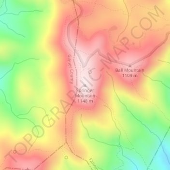
Naam: Topografische kaart Springer Mountain, hoogte, reliëf.
Locatie: Springer Mountain, Fannin County, Georgia, United States (34.62660 -84.19358 34.62670 -84.19348)
Gemiddelde hoogte: 941 m
Minimale hoogte: 670 m
Maximale hoogte: 1.141 m
Springer Mountain is a mountain located in the Chattahoochee National Forest on the border of Fannin and Gilmer counties. Located in the Blue Ridge Mountains in northern Georgia, the mountain has an elevation of about 3,782 feet (1,153 m). Springer Mountain serves as the southern terminus for the Appalachian and Benton MacKaye trails.
Andere topografische kaarten
Klik op een kaart om zijn topografie, zijn hoogte en zijn reliëf te bekijken.
Blue Ridge
United States > Georgia > Fannin County
Blue Ridge, Fannin County, Georgia, United States
Gemiddelde hoogte: 535 m
Wilscot
United States > Georgia > Fannin County
Wilscot, Fannin County, Georgia, United States
Gemiddelde hoogte: 614 m
Aska
United States > Georgia > Fannin County
Aska, Fannin County, Georgia, United States
Gemiddelde hoogte: 629 m
Greens Mill
United States > Georgia > Fannin County
Greens Mill, Fannin County, Georgia, 30513, United States
Gemiddelde hoogte: 566 m
Dial
United States > Georgia > Fannin County
Dial, Fannin County, Georgia, United States
Gemiddelde hoogte: 612 m
Colwell
United States > Georgia > Fannin County
Colwell, Fannin County, Georgia, United States
Gemiddelde hoogte: 630 m
Higdon
United States > Georgia > Fannin County
Higdon, Fannin County, Georgia, 30541, United States
Gemiddelde hoogte: 595 m
Lake Blue Ridge
United States > Georgia > Fannin County > Morganton
Lake Blue Ridge, Morganton, Fannin County, Georgia, United States
Gemiddelde hoogte: 572 m
Cordell Mountain
United States > Georgia > Fannin County
Cordell Mountain, Fannin County, Georgia, 30559, United States
Gemiddelde hoogte: 601 m
Ocoee River
United States > Georgia > Fannin County
Ocoee River, Fannin County, East Tennessee, Georgia, 30572, United States
Gemiddelde hoogte: 579 m
McCaysville
United States > Georgia > Fannin County
McCaysville, Fannin County, Georgia, United States
Gemiddelde hoogte: 484 m
Morganton
United States > Georgia > Fannin County
Morganton, Fannin County, Georgia, United States
Gemiddelde hoogte: 538 m
Mineral Bluff
United States > Georgia > Fannin County
Mineral Bluff, Fannin County, Georgia, 30559, United States
Gemiddelde hoogte: 516 m
Kyle
United States > Georgia > Fannin County
Kyle, Fannin County, Georgia, 30555, United States
Gemiddelde hoogte: 508 m
Epworth
United States > Georgia > Fannin County > Epworth
Epworth, Fannin County, Georgia, 30555, United States
Gemiddelde hoogte: 524 m
Loving
United States > Georgia > Fannin County > Loving
Loving, Fannin County, Georgia, 30560, United States
Gemiddelde hoogte: 577 m