
Topografische kaart Indianapolis
Interactieve kaart
Klik op de kaart om de hoogte weer te geven.
Over deze kaart
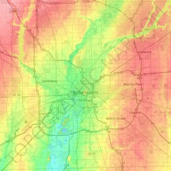
Naam: Topografische kaart Indianapolis, hoogte, reliëf.
Locatie: Indianapolis, Marion County, Indiana, United States (39.63216 -86.32812 39.92753 -85.93804)
Gemiddelde hoogte: 241 m
Minimale hoogte: 196 m
Maximale hoogte: 283 m
Indianapolis is located within a physiographic province known as the Tipton Till Plain, a flat, gently rolling terrain underlain by glacial deposits known as till. The lowest point in the city is about 650 feet (198 m) above mean sea level, with the highest natural elevation at about 900 feet (274 m) above sea level. Few hills or short ridges, known as kames, rise about 100 feet (30 m) to 130 feet (40 m) above the surrounding terrain. The city lies just north of the Indiana Uplands, a region characterized by rolling hills and high limestone content.
Andere topografische kaarten
Klik op een kaart om zijn topografie, zijn hoogte en zijn reliëf te bekijken.
Eagle Creek Park
United States > Indiana > Marion County > Indianapolis
Eagle Creek Park, Indianapolis, Marion County, Indiana, 46253, United States
Gemiddelde hoogte: 256 m
Fort Harrison State Park
United States > Indiana > Marion County > Indianapolis
Fort Harrison State Park, Indianapolis, Marion County, Indiana, United States
Gemiddelde hoogte: 251 m
West Newton
United States > Indiana > Marion County > Indianapolis
West Newton, Indianapolis, Marion County, Indiana, 46183, United States
Gemiddelde hoogte: 228 m
White River
United States > Indiana > Marion County > Indianapolis > Ravenswood
White River, Ravenswood, Indianapolis, Marion County, Indiana, 46240, United States
Gemiddelde hoogte: 227 m
Wellington
United States > Indiana > Marion County > Indianapolis
Wellington, Indianapolis, Marion County, Indiana, 46220, United States
Gemiddelde hoogte: 229 m
Maple Ridge
United States > Indiana > Marion County > Indianapolis
Maple Ridge, Indianapolis, Marion County, Indiana, 46183, United States
Gemiddelde hoogte: 234 m
Southport
United States > Indiana > Marion County
Southport, Marion County, Indiana, United States
Gemiddelde hoogte: 239 m
New Bethel
United States > Indiana > Marion County > Indianapolis
New Bethel, Indianapolis, Marion County, Indiana, 44623, United States
Gemiddelde hoogte: 257 m
Legendary Hills
United States > Indiana > Marion County > Indianapolis
Legendary Hills, Indianapolis, Marion County, Indiana, 46278, United States
Gemiddelde hoogte: 258 m
Drexel Gardens
United States > Indiana > Marion County > Indianapolis
Drexel Gardens, Indianapolis, Marion County, Indiana, 46241, United States
Gemiddelde hoogte: 226 m
Lawrence
United States > Indiana > Marion County
Lawrence, Marion County, Indiana, United States
Gemiddelde hoogte: 254 m
Lindenwood
United States > Indiana > Marion County > Indianapolis
Lindenwood, Indianapolis, Marion County, Indiana, 46217, United States
Gemiddelde hoogte: 227 m
Sterling Heights
United States > Indiana > Marion County > Indianapolis > Sterling Heights
Sterling Heights, Indianapolis, Marion County, Indiana, 46251, United States
Gemiddelde hoogte: 238 m
Glendale Heights
United States > Indiana > Marion County > Indianapolis
Glendale Heights, Indianapolis, Marion County, Indiana, 46220, United States
Gemiddelde hoogte: 229 m
Beech Grove
United States > Indiana > Marion County
Beech Grove, Marion County, Indiana, 46107, United States
Gemiddelde hoogte: 247 m
Crows Nest
United States > Indiana > Marion County
Crows Nest, Marion County, Indiana, United States
Gemiddelde hoogte: 229 m
Newfields
United States > Indiana > Marion County > Indianapolis > Shooters Hill
Newfields, Shooters Hill, Indianapolis, Marion County, Indiana, 46208, United States
Gemiddelde hoogte: 226 m