
Topografische kaart Garganta das Negras
Interactieve kaart
Klik op de kaart om de hoogte weer te geven.
Over deze kaart
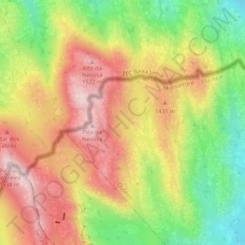
Naam: Topografische kaart Garganta das Negras, hoogte, reliëf.
Locatie: Garganta das Negras, Outeiro, Montalegre, Vila Real, Portugal (41.81518 -8.04659 41.83518 -8.02659)
Gemiddelde hoogte: 1.346 m
Minimale hoogte: 1.138 m
Maximale hoogte: 1.531 m