
Topografische kaart Lockhart Oil Field
Interactieve kaart
Klik op de kaart om de hoogte weer te geven.
Over deze kaart
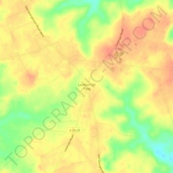
Naam: Topografische kaart Lockhart Oil Field, hoogte, reliëf.
Gemiddelde hoogte: 126 m
Minimale hoogte: 96 m
Maximale hoogte: 141 m
Andere topografische kaarten
Klik op een kaart om zijn topografie, zijn hoogte en zijn reliëf te bekijken.
White Hills
United States > South Carolina > Kershaw County > Elgin
White Hills, Elgin, Kershaw County, South Carolina, United States
Gemiddelde hoogte: 97 m
Lugoff
United States > South Carolina > Kershaw County
Lugoff, Kershaw County, South Carolina, United States
Gemiddelde hoogte: 69 m
Camden
United States > South Carolina > Kershaw County
Camden, Kershaw County, South Carolina, United States
Gemiddelde hoogte: 68 m
Lake Wateree
United States > South Carolina > Kershaw County
Lake Wateree, Kershaw County, South Carolina, United States
Gemiddelde hoogte: 109 m
Lake Wateree
United States > South Carolina > Kershaw County
Lake Wateree, Kershaw County, South Carolina, United States
Gemiddelde hoogte: 76 m
Arrowwood
United States > South Carolina > Kershaw County
Arrowwood, Kershaw County, South Carolina, 29020, United States
Gemiddelde hoogte: 74 m
Woodland Forest
United States > South Carolina > Kershaw County > Lugoff
Woodland Forest, Lugoff, Kershaw County, South Carolina, 29078, United States
Gemiddelde hoogte: 65 m
Green Valley
United States > South Carolina > Kershaw County > Green Valley
Green Valley, Kershaw County, South Carolina, United States
Gemiddelde hoogte: 59 m