
Topografische kaart Floris
Interactieve kaart
Klik op de kaart om de hoogte weer te geven.
Over deze kaart
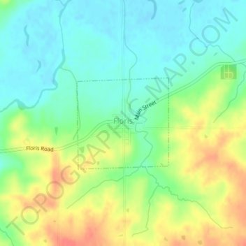
Naam: Topografische kaart Floris, hoogte, reliëf.
Locatie: Floris, Davis County, Iowa, United States (40.85979 -92.33939 40.86980 -92.32611)
Gemiddelde hoogte: 218 m
Minimale hoogte: 197 m
Maximale hoogte: 250 m
Andere topografische kaarten
Klik op een kaart om zijn topografie, zijn hoogte en zijn reliëf te bekijken.
Pulaski
United States > Iowa > Davis County
Pulaski, Davis County, Iowa, United States
Gemiddelde hoogte: 250 m
Drakesville
United States > Iowa > Davis County
Drakesville, Davis County, Iowa, United States
Gemiddelde hoogte: 262 m
Chequest
United States > Iowa > Davis County
Chequest, Davis County, Iowa, United States
Gemiddelde hoogte: 232 m
Ash Grove
United States > Iowa > Davis County
Ash Grove, Davis County, Iowa, United States
Gemiddelde hoogte: 247 m
West Grove
United States > Iowa > Davis County
West Grove, Davis County, Iowa, United States
Gemiddelde hoogte: 281 m
Troy
United States > Iowa > Davis County
Troy, Davis County, Iowa, United States
Gemiddelde hoogte: 237 m
Bloomfield
United States > Iowa > Davis County
Bloomfield, Davis County, Iowa, United States
Gemiddelde hoogte: 261 m
Blackhawk
United States > Iowa > Davis County
Blackhawk, Davis County, Iowa, United States
Gemiddelde hoogte: 243 m