
Topografische kaart Cliftondale Park
Interactieve kaart
Klik op de kaart om de hoogte weer te geven.
Over deze kaart
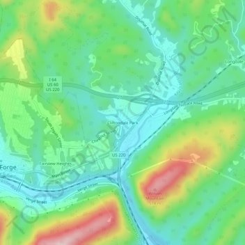
Naam: Topografische kaart Cliftondale Park, hoogte, reliëf.
Gemiddelde hoogte: 394 m
Minimale hoogte: 307 m
Maximale hoogte: 588 m
Andere topografische kaarten
Klik op een kaart om zijn topografie, zijn hoogte en zijn reliëf te bekijken.
Iron Gate
United States > Virginia > Alleghany County
Iron Gate, Alleghany County, Virginia, 24448, United States
Gemiddelde hoogte: 371 m
Callaghan
United States > Virginia > Alleghany County
Callaghan, Alleghany County, Virginia, United States
Gemiddelde hoogte: 490 m
Backbone
United States > Virginia > Alleghany County
Backbone, Alleghany County, Virginia, United States
Gemiddelde hoogte: 571 m
Low Moor
United States > Virginia > Alleghany County
Low Moor, Alleghany County, Virginia, United States
Gemiddelde hoogte: 446 m
Clifton Forge
United States > Virginia > Alleghany County
Clifton Forge, Alleghany County, Virginia, 24422, United States
Gemiddelde hoogte: 395 m
Lewis Mountain
United States > Virginia > Alleghany County
Lewis Mountain, Alleghany County, Virginia, United States
Gemiddelde hoogte: 742 m