
Topografische kaart Sour El Ghozlane
Interactieve kaart
Klik op de kaart om de hoogte weer te geven.
Sour El Ghozlane
On the other hand, its administrative and military status reveals that it was definitively subjected to the order of the Roman Empire with the status of autonomous city of the Roman province (free zone: region of Algiers to Bou-Saada) caesarean. Auzia is a large city of ovoid form, destined to serve as capital in this region of central Algeria, Auguste had it endowed with several public edifices: a forum (present room of the festivals), several temples, a curia, a market, a theater and large thermal baths. Auzia was erected on a hill at a moderate altitude, where to this day a wall was in good condition in some places, revealing a kind of citadel which protected the inhabitants.
Over deze kaart
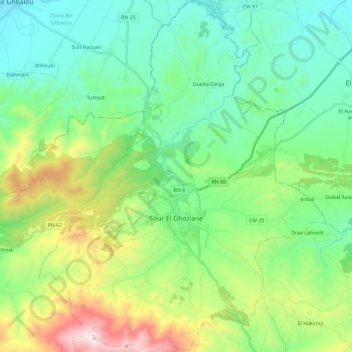
Naam: Topografische kaart Sour El Ghozlane, hoogte, reliëf.
Locatie: Sour El Ghozlane, Sour El Ghozlane District, Bouira, Algeria (36.07590 3.60055 36.26362 3.79039)
Gemiddelde hoogte: 934 m
Minimale hoogte: 609 m
Maximale hoogte: 1.807 m
Andere topografische kaarten
Klik op een kaart om zijn topografie, zijn hoogte en zijn reliëf te bekijken.
Haouche Delbi
Algeria > Bouira > Sour El Ghozlane District > Sour El Ghozlane
Gemiddelde hoogte: 885 m