Geolokaliseren

Topografische kaart Rockland

Interactieve kaart

Klik op de kaart om de hoogte weer te geven.

Over deze kaart

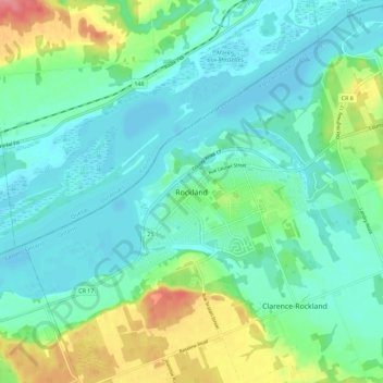
Naam: Topografische kaart Rockland, hoogte, reliëf.

Locatie: Rockland, Clarence-Rockland, Prescott and Russell Counties, Eastern Ontario, Ontario, K4K 1A0, Canada (45.50858 -75.33156 45.58858 -75.25156)

Gemiddelde hoogte: 59 m

Minimale hoogte: 38 m

Maximale hoogte: 120 m

Andere topografische kaarten

Klik op een kaart om zijn topografie, zijn hoogte en zijn reliëf te bekijken.

Alfred and Plantagenet

Canada > Ontario > Prescott and Russell Counties

Alfred and Plantagenet, Prescott and Russell Counties, Eastern Ontario, Ontario, Canada

Gemiddelde hoogte: 71 m

Champlain

Canada > Ontario > Prescott and Russell Counties

Champlain, Prescott and Russell Counties, Eastern Ontario, Ontario, Canada

Gemiddelde hoogte: 68 m

The Nation

Canada > Ontario > Prescott and Russell Counties

The Nation, Prescott and Russell Counties, Eastern Ontario, Ontario, Canada

Gemiddelde hoogte: 72 m

Prescott and Russell Counties

Canada > Ontario > Prescott and Russell Counties

Prescott and Russell Counties, Eastern Ontario, Ontario, Canada

Gemiddelde hoogte: 98 m