
Doe een donatie
Rust jezelf uit voor je volgende avontuur:
Als Amazon-partner verdient deze site een commissie op in aanmerking komende aankopen, zonder extra kosten voor jou.
Topografische kaart Cedar Run
Klik op de kaart om de hoogte weer te geven.
Doe een donatie
Rust jezelf uit voor je volgende avontuur:
Als Amazon-partner verdient deze site een commissie op in aanmerking komende aankopen, zonder extra kosten voor jou.
Over deze kaart
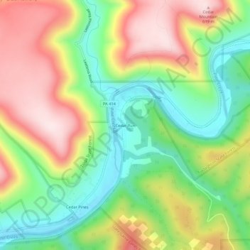
Naam: Topografische kaart Cedar Run, hoogte, reliëf.
Gemiddelde hoogte: 405 m
Minimale hoogte: 227 m
Maximale hoogte: 623 m
Doe een donatie
Rust jezelf uit voor je volgende avontuur:
Als Amazon-partner verdient deze site een commissie op in aanmerking komende aankopen, zonder extra kosten voor jou.
Andere topografische kaarten
Klik op een kaart om zijn topografie, zijn hoogte en zijn reliëf te bekijken.
Cascade Township
United States > Pennsylvania > Lycoming County
According to the United States Census Bureau, the township has a total area of 39.5 square miles (102.4 km2), of which 39.2 square miles (101.5 km2) are land and 0.3 square miles (0.8 km2), or 0.81%, are water. The northern part of the township drains to Pleasant Stream, which flows west to join Lycoming Creek…
Gemiddelde hoogte: 459 m
Doe een donatie
Rust jezelf uit voor je volgende avontuur:
Als Amazon-partner verdient deze site een commissie op in aanmerking komende aankopen, zonder extra kosten voor jou.
Doe een donatie
Rust jezelf uit voor je volgende avontuur:
Als Amazon-partner verdient deze site een commissie op in aanmerking komende aankopen, zonder extra kosten voor jou.
Doe een donatie
Rust jezelf uit voor je volgende avontuur:
Als Amazon-partner verdient deze site een commissie op in aanmerking komende aankopen, zonder extra kosten voor jou.
McHenry Township
United States > Pennsylvania > Lycoming County
According to the United States Census Bureau, the township has a total area of 76.7 square miles (198.6 km2), of which 76.2 square miles (197.4 km2) are land and 0.46 square miles (1.2 km2), or 0.62%, are water. Pine Creek runs through the center of the township at the bottom of Pine Creek Gorge, with creek…
Gemiddelde hoogte: 506 m
Cascade Township
United States > Pennsylvania > Lycoming County
According to the United States Census Bureau, the township has a total area of 39.5 square miles (102.4 km2), of which 39.2 square miles (101.5 km2) are land and 0.3 square miles (0.8 km2), or 0.81%, are water. The northern part of the township drains to Pleasant Stream, which flows west to join Lycoming Creek…
Gemiddelde hoogte: 459 m
Doe een donatie
Rust jezelf uit voor je volgende avontuur:
Als Amazon-partner verdient deze site een commissie op in aanmerking komende aankopen, zonder extra kosten voor jou.
Doe een donatie
Rust jezelf uit voor je volgende avontuur:
Als Amazon-partner verdient deze site een commissie op in aanmerking komende aankopen, zonder extra kosten voor jou.