
Topografische kaart Sungai Sering
Interactieve kaart
Klik op de kaart om de hoogte weer te geven.
Over deze kaart
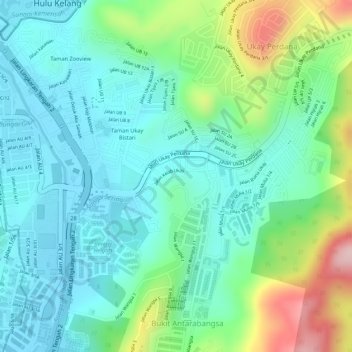
Naam: Topografische kaart Sungai Sering, hoogte, reliëf.
Gemiddelde hoogte: 118 m
Minimale hoogte: 49 m
Maximale hoogte: 293 m
Andere topografische kaarten
Klik op een kaart om zijn topografie, zijn hoogte en zijn reliëf te bekijken.
Bukit Tabur Extra
Malaysia > Ampang Jaya Municipal Council
Bukit Tabur Extra, Ampang Jaya Municipal Council, Gombak, 53100, Malaysia
Gemiddelde hoogte: 161 m
Hulu Kelang
Malaysia > Ampang Jaya Municipal Council
Hulu Kelang, Ampang Jaya Municipal Council, Gombak, 53100, Malaysia
Gemiddelde hoogte: 147 m