
Doe een donatie
Rust jezelf uit voor je volgende avontuur:
Als Amazon-partner verdient deze site een commissie op in aanmerking komende aankopen, zonder extra kosten voor jou.
Topografische kaart McAdoo
Klik op de kaart om de hoogte weer te geven.
Doe een donatie
Rust jezelf uit voor je volgende avontuur:
Als Amazon-partner verdient deze site een commissie op in aanmerking komende aankopen, zonder extra kosten voor jou.
McAdoo
According to the United States Census Bureau, the borough has a total area of 0.3 square miles (0.78 km2), all land. McAdoo's elevation is 1700 feet above sea level. It is on the crest of Broad Mountain and straddles the divide between the Delaware and Susquehanna watersheds. Pennsylvania Route 309 (Kennedy Drive) is the main north-to-south thoroughfare. Interstate 81 runs a short distance west of town and parallel to PA 309. The two routes have an access highway connecting them just south of McAdoo at exit 138 of I-81. McAdoo has a warm-summer humid continental climate (Dfb) and the hardiness zone is 6a. Average monthly temperatures range from 23.5 °F in January to 70.1 °F in July.
Doe een donatie
Rust jezelf uit voor je volgende avontuur:
Als Amazon-partner verdient deze site een commissie op in aanmerking komende aankopen, zonder extra kosten voor jou.
Over deze kaart
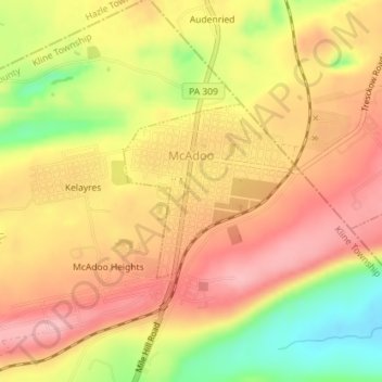
Naam: Topografische kaart McAdoo, hoogte, reliëf.
Gemiddelde hoogte: 528 m
Minimale hoogte: 445 m
Maximale hoogte: 580 m
Doe een donatie
Rust jezelf uit voor je volgende avontuur:
Als Amazon-partner verdient deze site een commissie op in aanmerking komende aankopen, zonder extra kosten voor jou.
Andere topografische kaarten
Klik op een kaart om zijn topografie, zijn hoogte en zijn reliëf te bekijken.
Park Place
United States > Pennsylvania > Schuylkill County > Mahanoy Township
Gemiddelde hoogte: 515 m
Andreas
United States > Pennsylvania > Schuylkill County > West Penn Township
Gemiddelde hoogte: 250 m
Doe een donatie
Rust jezelf uit voor je volgende avontuur:
Als Amazon-partner verdient deze site een commissie op in aanmerking komende aankopen, zonder extra kosten voor jou.
Blue Mountain
United States > Pennsylvania > Schuylkill County > Washington Township
The ridge of Blue Mountain runs for 150 miles (240 km) through Pennsylvania, reaching an elevation of 2,270 feet (690 m) above sea level just north of the Pennsylvania Turnpike, near the borough of Newburg. Most of the ridgecrest, however, only reaches between 1,400 and 1,700 feet (430 and 520 m) in elevation.…
Gemiddelde hoogte: 226 m
Snyders
United States > Pennsylvania > Schuylkill County > West Penn Township
Gemiddelde hoogte: 242 m
Andreas
United States > Pennsylvania > Schuylkill County > West Penn Township
Gemiddelde hoogte: 250 m
Doe een donatie
Rust jezelf uit voor je volgende avontuur:
Als Amazon-partner verdient deze site een commissie op in aanmerking komende aankopen, zonder extra kosten voor jou.
Blue Mountain
United States > Pennsylvania > Schuylkill County > Washington Township
The ridge of Blue Mountain runs for 150 miles (240 km) through Pennsylvania, reaching an elevation of 2,270 feet (690 m) above sea level just north of the Pennsylvania Turnpike, near the borough of Newburg. Most of the ridgecrest, however, only reaches between 1,400 and 1,700 feet (430 and 520 m) in elevation.…
Gemiddelde hoogte: 226 m
Irving
United States > Pennsylvania > Schuylkill County > Pine Grove Township
Gemiddelde hoogte: 199 m
Doe een donatie
Rust jezelf uit voor je volgende avontuur:
Als Amazon-partner verdient deze site een commissie op in aanmerking komende aankopen, zonder extra kosten voor jou.
Blue Mountain
United States > Pennsylvania > Schuylkill County > Washington Township
The ridge of Blue Mountain runs for 150 miles (240 km) through Pennsylvania, reaching an elevation of 2,270 feet (690 m) above sea level just north of the Pennsylvania Turnpike, near the borough of Newburg. Most of the ridgecrest, however, only reaches between 1,400 and 1,700 feet (430 and 520 m) in elevation.…
Gemiddelde hoogte: 226 m
Nuremberg
United States > Pennsylvania > Schuylkill County > North Union Township
Gemiddelde hoogte: 377 m