
Topografische kaart Garur
Interactieve kaart
Klik op de kaart om de hoogte weer te geven.
Over deze kaart
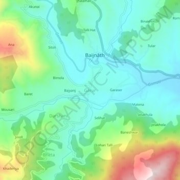
Naam: Topografische kaart Garur, hoogte, reliëf.
Locatie: Garur, Garud, Bageshwar District, Uttarakhand, 263641, India (29.88067 79.59380 29.92067 79.63380)
Gemiddelde hoogte: 1.230 m
Minimale hoogte: 1.094 m
Maximale hoogte: 1.581 m
Andere topografische kaarten
Klik op een kaart om zijn topografie, zijn hoogte en zijn reliëf te bekijken.
Lakhani
India > Uttarakhand > Garud
Lakhani, Garud, Bageshwar District, Uttarakhand, 263641, India
Gemiddelde hoogte: 1.438 m
Nakuri
India > Uttarakhand > Garud
Nakuri, Garud, Bageshwar, Uttarakhand, 263639, India
Gemiddelde hoogte: 1.631 m