
Topografische kaart Dubnica nad Váhom
Interactieve kaart
Klik op de kaart om de hoogte weer te geven.
Over deze kaart
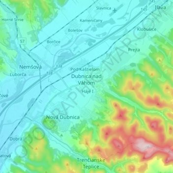
Naam: Topografische kaart Dubnica nad Váhom, hoogte, reliëf.
Gemiddelde hoogte: 309 m
Minimale hoogte: 215 m
Maximale hoogte: 700 m
It is located on the Váh river, in the Ilava Basin, between the White Carpathians and Strážovské vrchy mountains, at an altitude of 242 metres. The town's cadastral area is composed of Dubnica and "city part" Prejta, annexed in 1973.