
Topografische kaart Syracuse
Interactieve kaart
Klik op de kaart om de hoogte weer te geven.
Over deze kaart
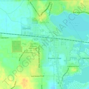
Naam: Topografische kaart Syracuse, hoogte, reliëf.
Locatie: Syracuse, Kosciusko County, Indiana, United States (41.40303 -85.76861 41.43607 -85.73412)
Gemiddelde hoogte: 267 m
Minimale hoogte: 257 m
Maximale hoogte: 283 m
Andere topografische kaarten
Klik op een kaart om zijn topografie, zijn hoogte en zijn reliëf te bekijken.
Pierceton
United States > Indiana > Kosciusko County
Pierceton, Kosciusko County, Indiana, United States
Gemiddelde hoogte: 280 m
Warsaw
United States > Indiana > Kosciusko County
Warsaw, Kosciusko County, Indiana, 46580, United States
Gemiddelde hoogte: 256 m
Tippecanoe Lake
United States > Indiana > Kosciusko County
Tippecanoe Lake, Kosciusko County, Indiana, United States
Gemiddelde hoogte: 263 m
Winona Lake
United States > Indiana > Kosciusko County
Winona Lake, Kosciusko County, Indiana, 46590, United States
Gemiddelde hoogte: 257 m
Atwood
United States > Indiana > Kosciusko County
Atwood, Kosciusko County, Indiana, 46502, United States
Gemiddelde hoogte: 246 m
Warsaw
United States > Indiana > Kosciusko County > Warsaw > Warsaw
Warsaw, Kosciusko County, Indiana, 4650, United States
Gemiddelde hoogte: 255 m
Highlands Park
United States > Indiana > Kosciusko County > Highlands Park
Highlands Park, Kosciusko County, Indiana, 46852, United States
Gemiddelde hoogte: 262 m
Lake Wawasee
United States > Indiana > Kosciusko County > Syracuse
Lake Wawasee, Syracuse, Kosciusko County, Indiana, 46567, United States
Gemiddelde hoogte: 267 m
Silver Point
United States > Indiana > Kosciusko County > Forest Glen
Silver Point, Forest Glen, Kosciusko County, Indiana, 46538, United States
Gemiddelde hoogte: 264 m