
Topografische kaart Frederiksted
Interactieve kaart
Klik op de kaart om de hoogte weer te geven.
Over deze kaart
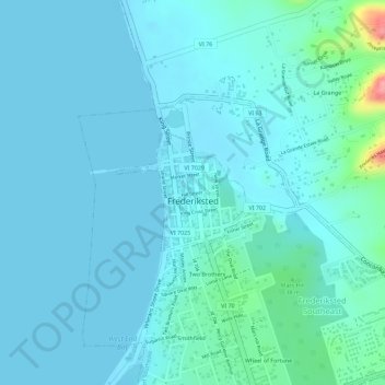
Naam: Topografische kaart Frederiksted, hoogte, reliëf.
Gemiddelde hoogte: 14 m
Minimale hoogte: -2 m
Maximale hoogte: 110 m
Rainforests are located on this western side of St. Croix due to the topography and 1,400 foot peaks and the tradewinds. This rainforest climate is unique to the Frederiksted side of St. Croix.
Andere topografische kaarten
Klik op een kaart om zijn topografie, zijn hoogte en zijn reliëf te bekijken.
Saint Croix
United States > United States Virgin Islands > Saint Croix District > Christiansted
Saint Croix, Christiansted, Saint Croix District, United States Virgin Islands, United States
Gemiddelde hoogte: 11 m
Longford (Anna's Hope Village)
United States > United States Virgin Islands > Saint Croix District
Longford (Anna's Hope Village), Saint Croix District, United States Virgin Islands, 00824, United States
Gemiddelde hoogte: 49 m
Cartlon South
United States > United States Virgin Islands > Saint Croix District > Cartlon South
Cartlon South, Saint Croix District, United States Virgin Islands, 00840, United States
Gemiddelde hoogte: 23 m
Morningstar
United States > United States Virgin Islands > Saint Croix District > Morningstar
Morningstar, Saint Croix District, United States Virgin Islands, 00820, United States
Gemiddelde hoogte: 68 m
Virgin Islands
United States > United States Virgin Islands > Saint Croix District
Virgin Islands, Saint Croix District, United States Virgin Islands, United States
Gemiddelde hoogte: 2 m