
Topografische kaart Devils Lake
Interactieve kaart
Klik op de kaart om de hoogte weer te geven.
Over deze kaart
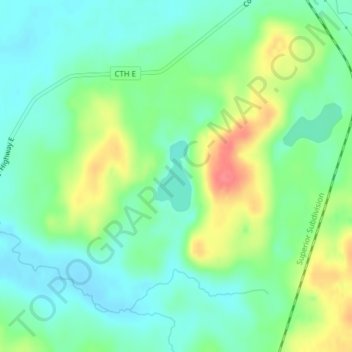
Naam: Topografische kaart Devils Lake, hoogte, reliëf.
Gemiddelde hoogte: 367 m
Minimale hoogte: 345 m
Maximale hoogte: 409 m
Andere topografische kaarten
Klik op een kaart om zijn topografie, zijn hoogte en zijn reliëf te bekijken.
Tomahawk Lake
United States > Wisconsin > Washburn County
Tomahawk Lake, Town of Casey, Washburn County, Wisconsin, United States
Gemiddelde hoogte: 318 m
Slim Lake
United States > Wisconsin > Washburn County
Slim Lake, Town of Birchwood, Washburn County, Wisconsin, United States
Gemiddelde hoogte: 404 m
Town of Spooner
United States > Wisconsin > Washburn County
Town of Spooner, Washburn County, Wisconsin, 54801, United States
Gemiddelde hoogte: 342 m
Chicog Lake
United States > Wisconsin > Washburn County
Chicog Lake, Town of Chicog, Washburn County, Wisconsin, United States
Gemiddelde hoogte: 314 m
Spooner
United States > Wisconsin > Washburn County
Spooner, Washburn County, Wisconsin, United States
Gemiddelde hoogte: 336 m
Town of Chicog
United States > Wisconsin > Washburn County
Town of Chicog, Washburn County, Wisconsin, United States
Gemiddelde hoogte: 310 m
Minong
United States > Wisconsin > Washburn County
Minong, Washburn County, Wisconsin, United States
Gemiddelde hoogte: 330 m
Crystal Mountain
United States > Wisconsin > Washburn County
Crystal Mountain, Town of Spooner, Washburn County, Wisconsin, United States
Gemiddelde hoogte: 344 m
Shell Lake
United States > Wisconsin > Washburn County
Shell Lake, Washburn County, Wisconsin, 53871, United States
Gemiddelde hoogte: 376 m
Stone Lake
United States > Wisconsin > Washburn County
Stone Lake, Town of Stone Lake, Washburn County, Wisconsin, 54876, United States
Gemiddelde hoogte: 405 m