
Doe een donatie
Rust jezelf uit voor je volgende avontuur:
Als Amazon-partner verdient deze site een commissie op in aanmerking komende aankopen, zonder extra kosten voor jou.
Topografische kaart Gosbach
Klik op de kaart om de hoogte weer te geven.
Doe een donatie
Rust jezelf uit voor je volgende avontuur:
Als Amazon-partner verdient deze site een commissie op in aanmerking komende aankopen, zonder extra kosten voor jou.
Over deze kaart
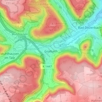
Naam: Topografische kaart Gosbach, hoogte, reliëf.
Gemiddelde hoogte: 650 m
Minimale hoogte: 497 m
Maximale hoogte: 789 m
Doe een donatie
Rust jezelf uit voor je volgende avontuur:
Als Amazon-partner verdient deze site een commissie op in aanmerking komende aankopen, zonder extra kosten voor jou.
Andere topografische kaarten
Klik op een kaart om zijn topografie, zijn hoogte en zijn reliëf te bekijken.
73312
Germany > Baden-Württemberg > Landkreis Göppingen > Geislingen an der Steige > Weiler ob Helfenstein
Gemiddelde hoogte: 615 m
Ottenbach
Germany > Baden-Württemberg > Landkreis Göppingen
Cycling: Nationally known is Ottenbach for the organization and conduct of mass sports bike marathon "Alb-extreme". The itinerary leads annually on the last Sunday in June over a distance of 190, 210 and 260 km through the countryside of the Swabian Jura with many elevations.
Gemiddelde hoogte: 449 m
Doe een donatie
Rust jezelf uit voor je volgende avontuur:
Als Amazon-partner verdient deze site een commissie op in aanmerking komende aankopen, zonder extra kosten voor jou.
Geislingen an der Steige
Germany > Baden-Württemberg > Landkreis Göppingen
The importance of the Rorgensteig church for the religious life of the Geislingen community decreased since the elevation of the Geislingen Lady Chapel to a parish church (around 1393) and the construction of the present town church in the years 1424 to 1428. Rorgensteig with its mills had special significance…
Gemiddelde hoogte: 612 m
Hohenstadt
Germany > Baden-Württemberg > Landkreis Göppingen
The municipality (Gemeinde) of Hohenstadt is situated in the district of Göppingen, of the German state of Baden-Württemberg. Hohenstadt lies at the southernmost tip of Göppingen's district, along its border with the Alb-Danube district. The municipal area is physically located in the Middle Kuppenalb [de].…
Gemiddelde hoogte: 775 m
Eislingen/Fils
Germany > Baden-Württemberg > Landkreis Göppingen
The city (Stadt) of Eislingen is located in the north of the district of Göppingen, in the German state of Baden-Württemberg. Eislingen is physically located in the Fils river valley, at the mouth of the Krumm, in the central [de] and eastern foothills [de] of the Swabian Jura. Elevation above sea level in…
Gemiddelde hoogte: 369 m
Doe een donatie
Rust jezelf uit voor je volgende avontuur:
Als Amazon-partner verdient deze site een commissie op in aanmerking komende aankopen, zonder extra kosten voor jou.
Deggingen
Germany > Baden-Württemberg > Landkreis Göppingen > Deggingen
The municipality (Gemeinde) of Deggingen is found in the district of Göppingen, in Baden-Württemberg, one of the 16 States of the Federal Republic of Germany. Deggingen is physically located in the upper Fils river valley, in the Filsalb region of the Middle Kuppenalb . Elevation above sea level in the…
Gemiddelde hoogte: 643 m
Donzdorf
Germany > Baden-Württemberg > Landkreis Göppingen
Donzdorf is located in the valley of the river Lauter, a tributary of the Fils river, 12 km east of Göppingen, on an elevation between 334 and 749 metres.
Gemiddelde hoogte: 526 m
Geislingen an der Steige
Germany > Baden-Württemberg > Landkreis Göppingen
The importance of the Rorgensteig church for the religious life of the Geislingen community decreased since the elevation of the Geislingen Lady Chapel to a parish church (around 1393) and the construction of the present town church in the years 1424 to 1428. Rorgensteig with its mills had special significance…
Gemiddelde hoogte: 612 m
Doe een donatie
Rust jezelf uit voor je volgende avontuur:
Als Amazon-partner verdient deze site een commissie op in aanmerking komende aankopen, zonder extra kosten voor jou.