
Topografische kaart Athabasca Sand Dunes
Klik op de kaart om de hoogte weer te geven.
Over deze kaart
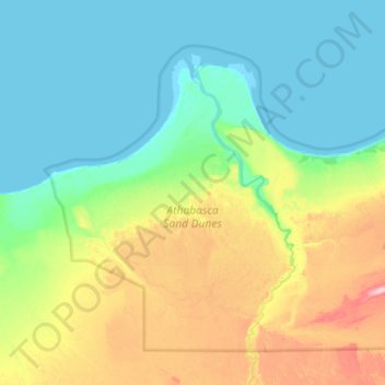
Naam: Topografische kaart Athabasca Sand Dunes, hoogte, reliëf.
Gemiddelde hoogte: 246 m
Minimale hoogte: 207 m
Maximale hoogte: 360 m
Andere topografische kaarten
Klik op een kaart om zijn topografie, zijn hoogte en zijn reliëf te bekijken.
Primrose Lake
Canada > Saskatchewan > Unorganized Division No. 18
Primrose Lake has a total surface area of 444 km2 (171 sq mi), 17.7 km2 (6.8 sq mi) of which is in Alberta, and an elevation of 559 metres (1,834 ft). It lies within muskeg and the boreal forest ecozone of Canada. There are several rivers and creeks that flow into the lake with Calder River on the northern…
Gemiddelde hoogte: 607 m