
Doe een donatie
Rust jezelf uit voor je volgende avontuur:
Als Amazon-partner verdient deze site een commissie op in aanmerking komende aankopen, zonder extra kosten voor jou.
Topografische kaart Nazareth
Klik op de kaart om de hoogte weer te geven.
Doe een donatie
Rust jezelf uit voor je volgende avontuur:
Als Amazon-partner verdient deze site een commissie op in aanmerking komende aankopen, zonder extra kosten voor jou.
Nazareth
As of the early 1990s, no city plans drafted by Nazareth Municipality have been approved by the government (both the British Mandate and later Israel) since 1942. This has left many people in Nazareth who vote in the city's municipal elections and receive services from its municipality effectively outside of the city's jurisdiction. Such areas include the Sharqiya and Jabal el-Daula quarters which are in Nazareth Illit's jurisdiction and whose residents had to acquire building permits from the latter city. Similarly, the Bilal neighborhood of the Safafra Quarter is located within Reineh's jurisdiction. In 1993, the residents of Bilal became official residents of Reineh. Nazareth's municipal plans for expansion prior to the establishment of Nazareth Illit, were to the north and east, areas that the latter city now occupy. Arab satellite towns are closely located to the north, west and southwest. Thus, the remaining area within the city's municipal boundaries available for expansion were to the northwest and the south, where the topography restricted urban development. After lobbying the Knesset and the Interior Ministry, el-Zoubi was able to have areas to the northwest of the city annexed to the municipality.
Doe een donatie
Rust jezelf uit voor je volgende avontuur:
Als Amazon-partner verdient deze site een commissie op in aanmerking komende aankopen, zonder extra kosten voor jou.
Over deze kaart
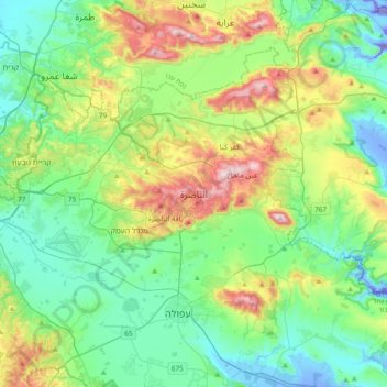
Naam: Topografische kaart Nazareth, hoogte, reliëf.
Locatie: Nazareth, Jezreel Subdistrict, North District, 16161, Israel (32.54663 35.14482 32.86663 35.46482)
Gemiddelde hoogte: 151 m
Minimale hoogte: -128 m
Maximale hoogte: 565 m
Doe een donatie
Rust jezelf uit voor je volgende avontuur:
Als Amazon-partner verdient deze site een commissie op in aanmerking komende aankopen, zonder extra kosten voor jou.