
Topografische kaart Barossa Valley District
Interactieve kaart
Klik op de kaart om de hoogte weer te geven.
Over deze kaart
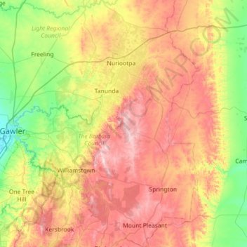
Naam: Topografische kaart Barossa Valley District, hoogte, reliëf.
Gemiddelde hoogte: 294 m
Minimale hoogte: 45 m
Maximale hoogte: 627 m
Andere topografische kaarten
Klik op een kaart om zijn topografie, zijn hoogte en zijn reliëf te bekijken.
Brenda Park
Australia > South Australia > Mid Murray Council
Brenda Park, Mid Murray Council, South Australia, 5320, Australia
Gemiddelde hoogte: 23 m
Dutton
Australia > South Australia > Mid Murray Council
Dutton, Mid Murray Council, South Australia, 5356, Australia
Gemiddelde hoogte: 366 m
Blanchetown
Australia > South Australia > Mid Murray Council
Blanchetown, Mid Murray Council, South Australia, 5357, Australia
Gemiddelde hoogte: 52 m
Sedan
Australia > South Australia > Mid Murray Council > Sedan
Sedan, Mid Murray Council, South Australia, 5353, Australia
Gemiddelde hoogte: 162 m