
Topografische kaart Antakya
Interactieve kaart
Klik op de kaart om de hoogte weer te geven.
Over deze kaart
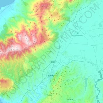
Naam: Topografische kaart Antakya, hoogte, reliëf.
Locatie: Antakya, Hatay, Mediterranean Region, Turkey (36.16188 35.92274 36.42382 36.40043)
Gemiddelde hoogte: 384 m
Minimale hoogte: 0 m
Maximale hoogte: 1.793 m
The city experiences a hot-summer Mediterranean climate (Köppen climate classification Csa) with hot and dry summers, and mild and wet winters; however due to its higher altitude, Antakya has slightly cooler temperatures than the coast.
Andere topografische kaarten
Klik op een kaart om zijn topografie, zijn hoogte en zijn reliëf te bekijken.