
Topografische kaart Isla Mina
Interactieve kaart
Klik op de kaart om de hoogte weer te geven.
Over deze kaart
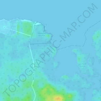
Naam: Topografische kaart Isla Mina, hoogte, reliëf.
Locatie: Isla Mina, Cristóbal, Distrito Colón, Colón, Panamá (9.39615 -79.85964 9.39625 -79.85954)
Gemiddelde hoogte: 3 m
Minimale hoogte: -1 m
Maximale hoogte: 27 m
Andere topografische kaarten
Klik op een kaart om zijn topografie, zijn hoogte en zijn reliëf te bekijken.
Esclusas de Gatún
Panamá > Colón > Distrito Colón > Cristóbal > Gatún
Esclusas de Gatún, Gatún, Cristóbal, Distrito Colón, Colón, Panamá
Gemiddelde hoogte: 17 m
Cristóbal
Panamá > Colón > Distrito Colón > Cristóbal
Cristóbal, Distrito Colón, Colón, Panamá
Gemiddelde hoogte: 46 m