Geolokaliseren

Topografische kaart Harrow

Klik op de kaart om de hoogte weer te geven.

👉 Easily get elevation data in JSON, GeoTIFF and KML formats using Elevation API
Bedankt voor het steunen van deze site ❤️
Doe een donatie

Rust jezelf uit voor je volgende avontuur:

Als Amazon-partner verdient deze site een commissie op in aanmerking komende aankopen, zonder extra kosten voor jou.

Over deze kaart

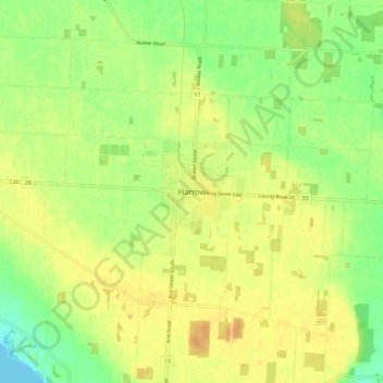
Naam: Topografische kaart Harrow, hoogte, reliëf.

Locatie: Harrow, Town of Essex, Essex County, Ontario, N0R 1G0, Canada (41.99559 -82.95836 42.07559 -82.87836)

Gemiddelde hoogte: 189 m

Minimale hoogte: 172 m

Maximale hoogte: 201 m

Andere topografische kaarten

Klik op een kaart om zijn topografie, zijn hoogte en zijn reliëf te bekijken.

Leamington

Canada > Ontario > Essex County

Gemiddelde hoogte: 177 m

Amherstburg

Canada > Ontario > Essex County

Gemiddelde hoogte: 178 m

Tecumseh

Canada > Ontario > Essex County

Gemiddelde hoogte: 183 m

Kingsville

Canada > Ontario > Essex County

Gemiddelde hoogte: 177 m

Lasalle

Canada > Ontario > Essex County

Gemiddelde hoogte: 179 m

Lakeshore

Canada > Ontario > Essex County

As in the rest of Essex County and Chatham-Kent, the terrain is extremely flat and regular. The terrain slopes very gently from the southern border of Lakeshore on Highway 8, with an average elevation of 188 m (617 ft), to the shore of Lake St. Clair at 176 m (577 ft). The highest land is in the southwestern…

Gemiddelde hoogte: 183 m

Leamington

Canada > Ontario > Essex County

Gemiddelde hoogte: 177 m

Tecumseh

Canada > Ontario > Essex County

Gemiddelde hoogte: 183 m

Kingsville

Canada > Ontario > Essex County

Gemiddelde hoogte: 177 m

Lakeshore

Canada > Ontario > Essex County

As in the rest of Essex County and Chatham-Kent, the terrain is extremely flat and regular. The terrain slopes very gently from the southern border of Lakeshore on Highway 8, with an average elevation of 188 m (617 ft), to the shore of Lake St. Clair at 176 m (577 ft). The highest land is in the southwestern…

Gemiddelde hoogte: 183 m

Lasalle

Canada > Ontario > Essex County

Gemiddelde hoogte: 179 m

Bedankt voor het steunen van deze site ❤️
Doe een donatie

Rust jezelf uit voor je volgende avontuur:

Als Amazon-partner verdient deze site een commissie op in aanmerking komende aankopen, zonder extra kosten voor jou.

Leamington

Canada > Ontario > Essex County

Gemiddelde hoogte: 177 m

Lakeshore

Canada > Ontario > Essex County

As in the rest of Essex County and Chatham-Kent, the terrain is extremely flat and regular. The terrain slopes very gently from the southern border of Lakeshore on Highway 8, with an average elevation of 188 m (617 ft), to the shore of Lake St. Clair at 176 m (577 ft). The highest land is in the southwestern…

Gemiddelde hoogte: 183 m

Lasalle

Canada > Ontario > Essex County

Gemiddelde hoogte: 179 m

Mersea

Canada > Ontario > Essex County > Leamington

Gemiddelde hoogte: 181 m

Rust jezelf uit voor je volgende avontuur:

🔌Reisadapters - Voor de grensstreken en internationale trips
🧥Windjacks - Bescherming tegen gure wind op de heuvels
🔥Camping Kooktoestellen - Warm eten onderweg tijdens hikes
🧤Outdoor Handschoenen - Bescherming tegen kou en wind tijdens hikes
🧥Softshell Jassen - Flexibele bescherming tegen wind en kou

Als Amazon-partner verdient deze site een commissie op in aanmerking komende aankopen, zonder extra kosten voor jou.