
Topografische kaart Leadville
Interactieve kaart
Klik op de kaart om de hoogte weer te geven.
Leadville
Leadville is the statutory city that is the county seat and only incorporated municipality in Lake County, Colorado, United States. The city population was 2,602 at the 2010 census and an estimated 2,762 in 2018. Leadville is situated at an elevation of 10,152 feet (3,094 m).
Over deze kaart
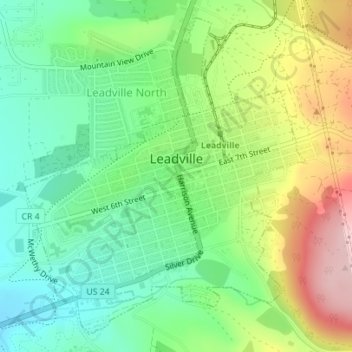
Naam: Topografische kaart Leadville, hoogte, reliëf.
Locatie: Leadville, Lake County, Colorado, United States of America (39.23730 -106.30754 39.25598 -106.27958)
Gemiddelde hoogte: 3.106 m
Minimale hoogte: 3.023 m
Maximale hoogte: 3.247 m