
Topografische kaart Minot
Interactieve kaart
Klik op de kaart om de hoogte weer te geven.
Over deze kaart
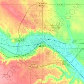
Naam: Topografische kaart Minot, hoogte, reliëf.
Locatie: Minot, Ward County, North Dakota, United States (48.19164 -101.34295 48.28304 -101.18767)
Gemiddelde hoogte: 510 m
Minimale hoogte: 467 m
Maximale hoogte: 558 m
The elevation of the river at the city center is 1,540 feet (470 m) above sea level. The valley sits 160 feet (49 m) below the surrounding plains; the elevation at the Minot International Airport on North Hill is 1,716 feet (523 m). The city has several small horseshoe-shaped oxbow lakes within its limits near the river, created by the Mouse's meandering course.
Andere topografische kaarten
Klik op een kaart om zijn topografie, zijn hoogte en zijn reliëf te bekijken.
Kenmare
United States > North Dakota > Ward County
Kenmare, Ward County, North Dakota, United States
Gemiddelde hoogte: 577 m
Burlington
United States > North Dakota > Ward County
Burlington, Ward County, North Dakota, United States
Gemiddelde hoogte: 500 m
Sawyer
United States > North Dakota > Ward County
Sawyer, Ward County, North Dakota, United States
Gemiddelde hoogte: 488 m
Berthold
United States > North Dakota > Ward County > Berthold
Berthold, Ward County, North Dakota, United States
Gemiddelde hoogte: 634 m