
Topografische kaart Salt Lake City
Interactieve kaart
Klik op de kaart om de hoogte weer te geven.
Salt Lake City
Salt Lake City has an area of 110.4 square miles (286 km2) and an average elevation of 4,327 feet (1,319 m) above sea level. The lowest point within the boundaries of the city is 4,210 feet (1,280 m) near the Jordan River and the Great Salt Lake, and the highest is Grandview Peak, at 9,410 feet (2,868 m).
Over deze kaart
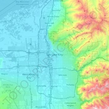
Naam: Topografische kaart Salt Lake City, hoogte, reliëf.
Gemiddelde hoogte: 1.625 m
Minimale hoogte: 1.278 m
Maximale hoogte: 3.231 m