
Topografische kaart Rangeley
Interactieve kaart
Klik op de kaart om de hoogte weer te geven.
Over deze kaart
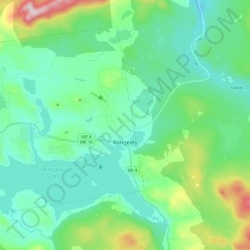
Naam: Topografische kaart Rangeley, hoogte, reliëf.
Locatie: Rangeley, Franklin County, Maine, United States (44.92166 -70.82363 45.03064 -70.62823)
Gemiddelde hoogte: 548 m
Minimale hoogte: 421 m
Maximale hoogte: 1.021 m
This climatic region has large seasonal temperature differences, with warm (and often humid) summers and cold (sometimes severely cold) winters. According to the Köppen Climate Classification system, Rangeley has a humid continental climate, abbreviated "Dfb" on climate maps. Similar to the rest of New England, snowfall is high in Rangeley, but due to the cold mean temperatures in winter, it remains on the ground for several months. Summer temperatures are moderated by the elevation and are thus cooler than other nearby towns.
Andere topografische kaarten
Klik op een kaart om zijn topografie, zijn hoogte en zijn reliëf te bekijken.
Madrid Township
United States > Maine > Franklin County
Madrid Township, Franklin County, Maine, United States
Gemiddelde hoogte: 522 m
Stratton
United States > Maine > Franklin County
Stratton, Franklin County, Maine, 04982, United States
Gemiddelde hoogte: 374 m
Coburn Gore
United States > Maine > Franklin County
Coburn Gore, Franklin County, Maine, United States
Gemiddelde hoogte: 467 m
Strong
United States > Maine > Franklin County
Strong, Franklin County, Maine, 04983, United States
Gemiddelde hoogte: 260 m
Farmington
United States > Maine > Franklin County
Farmington, Franklin County, Maine, United States
Gemiddelde hoogte: 192 m
New Vineyard
United States > Maine > Franklin County
New Vineyard, Franklin County, Maine, 04956, United States
Gemiddelde hoogte: 251 m
Eustis
United States > Maine > Franklin County
Eustis, Franklin County, Maine, United States
Gemiddelde hoogte: 413 m
Phillips
United States > Maine > Franklin County
Phillips, Franklin County, Maine, 04966, United States
Gemiddelde hoogte: 322 m