
Topografische kaart Cortina d'Ampezzo
Interactieve kaart
Klik op de kaart om de hoogte weer te geven.
Over deze kaart
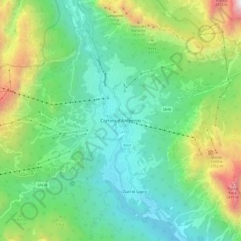
Naam: Topografische kaart Cortina d'Ampezzo, hoogte, reliëf.
Locatie: Cortina d'Ampezzo, Belluno, Veneto, 32043, Italy (46.49833 12.09735 46.57833 12.17735)
Gemiddelde hoogte: 1.649 m
Minimale hoogte: 1.081 m
Maximale hoogte: 3.084 m
Among the surrounding mountains are Tofane to the west, Pomagagnon to the north, Cristallo to the northeast, Faloria and Sorapiss to the east, and Becco di Mezzodì, Croda da Lago and Cinque Torri to the south. Monte Antelao (Nantelou in Ladin) is at 3264 m the highest mountain in the Ampezzo Dolomites and the second highest in the Dolomites. When the weather is good, Monte Antelao is clearly visible from the rive in Trieste on the Adriatic Sea. The town centre is located at an elevation of 1,224 metres (4,016 ft), the closest high peak is that of Tofana di Mezzo, which towers at 3,244 metres (10,643 ft). There are numerous fast flowing rivers, streams and small lakes in the territory, such as the Ghedina, Pianozes and d'Ajal, which fill particularly during the summer snow-melt season. Fauna include marmots, roe deer, chamois and hares and, on occasion, wolves, bears and lynx. Much of the area of Cortina is part of the "Natural Park of the Ampezzo Dolomites".