
Topografische kaart Ankeny
Interactieve kaart
Klik op de kaart om de hoogte weer te geven.
Ankeny
Like most of Polk County, Ankeny exists at the bottom area of the Des Moines Lobe, a topographical landscape area, in an area known as the Bemis Advance. The Lobe was formed during the Wisconsin glaciation leaving significant deposits resulting in an area with low relief.
Over deze kaart
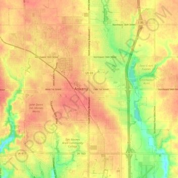
Naam: Topografische kaart Ankeny, hoogte, reliëf.
Locatie: Ankeny, Polk County, Iowa, 50023-3054, United States (41.69187 -93.64038 41.77187 -93.56038)
Gemiddelde hoogte: 289 m
Minimale hoogte: 255 m
Maximale hoogte: 307 m