
Topografische kaart Hughes
Interactieve kaart
Klik op de kaart om de hoogte weer te geven.
Over deze kaart
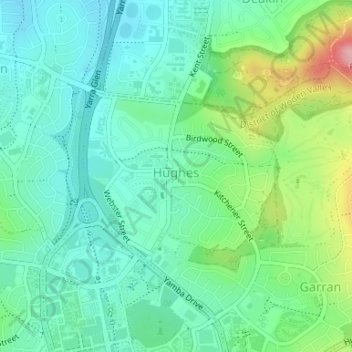
Naam: Topografische kaart Hughes, hoogte, reliëf.
Gemiddelde hoogte: 605 m
Minimale hoogte: 565 m
Maximale hoogte: 709 m
Andere topografische kaarten
Klik op een kaart om zijn topografie, zijn hoogte en zijn reliëf te bekijken.
Curtin
Australia > District of Woden Valley
Curtin, District of Woden Valley, Australian Capital Territory, Australia
Gemiddelde hoogte: 585 m
Farrer
Australia > District of Woden Valley
Farrer, District of Woden Valley, Australian Capital Territory, Australia
Gemiddelde hoogte: 673 m
Pearce
Australia > District of Woden Valley
Pearce, District of Woden Valley, Australian Capital Territory, Australia
Gemiddelde hoogte: 650 m
Isaacs
Australia > District of Woden Valley
Isaacs, District of Woden Valley, Australian Capital Territory, Australia
Gemiddelde hoogte: 691 m
Garran
Australia > District of Woden Valley
Garran, District of Woden Valley, Australian Capital Territory, Australia
Gemiddelde hoogte: 640 m
Mawson
Australia > District of Woden Valley
Mawson, District of Woden Valley, Australian Capital Territory, 2607, Australia
Gemiddelde hoogte: 640 m