
Topografische kaart Le Rey
Interactieve kaart
Klik op de kaart om de hoogte weer te geven.
Over deze kaart
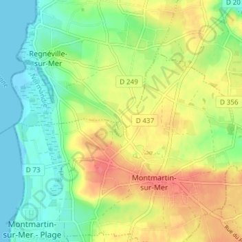
Naam: Topografische kaart Le Rey, hoogte, reliëf.
Gemiddelde hoogte: 26 m
Minimale hoogte: -1 m
Maximale hoogte: 59 m
Andere topografische kaarten
Klik op een kaart om zijn topografie, zijn hoogte en zijn reliëf te bekijken.
La Trancardière
France > Normandie > Manche > Regnéville-sur-Mer
La Trancardière, Regnéville-sur-Mer, Coutances, Manche, Normandie, France métropolitaine, 50590, France
Gemiddelde hoogte: 13 m
Les Hauts Vents
France > Normandie > Manche > Regnéville-sur-Mer
Les Hauts Vents, Regnéville-sur-Mer, Coutances, Manche, Normandie, France métropolitaine, 50590, France
Gemiddelde hoogte: 17 m