
Topografische kaart Brugelette
Interactieve kaart
Klik op de kaart om de hoogte weer te geven.
Over deze kaart
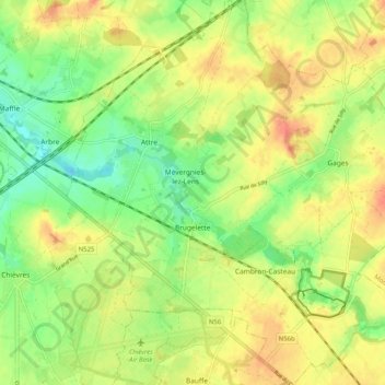
Naam: Topografische kaart Brugelette, hoogte, reliëf.
Locatie: Brugelette, Ath, Hainaut, Wallonia, Belgium (50.56932 3.81912 50.63403 3.91175)
Gemiddelde hoogte: 59 m
Minimale hoogte: 29 m
Maximale hoogte: 100 m
Andere topografische kaarten
Klik op een kaart om zijn topografie, zijn hoogte en zijn reliëf te bekijken.
Tongre-Notre-Dame
Belgium > Hainaut > Ath > Tongre-Notre-Dame
Tongre-Notre-Dame, Chièvres, Ath, Hainaut, Wallonia, 7951, Belgium
Gemiddelde hoogte: 56 m