
Topografische kaart Sandy Cove
Interactieve kaart
Klik op de kaart om de hoogte weer te geven.
Over deze kaart
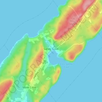
Naam: Topografische kaart Sandy Cove, hoogte, reliëf.
Gemiddelde hoogte: 28 m
Minimale hoogte: 0 m
Maximale hoogte: 111 m
Andere topografische kaarten
Klik op een kaart om zijn topografie, zijn hoogte en zijn reliëf te bekijken.
Ashmore
Canada > Nova Scotia > Digby County > Ashmore
Ashmore, Digby Municipal District, Digby County, Nova Scotia, B0W 3T0, Canada
Gemiddelde hoogte: 35 m
East Ferry
Canada > Nova Scotia > Digby County
East Ferry, Digby Municipal District, Digby County, Nova Scotia, B0V 1E0, Canada
Gemiddelde hoogte: 22 m
Digby
Canada > Nova Scotia > Digby County > Town of Digby
Digby, Town of Digby, Digby County, Nova Scotia, B0V 1A0, Canada
Gemiddelde hoogte: 16 m
Woodvale
Canada > Nova Scotia > Digby County
Woodvale, Clare Municipal District, Digby County, Nova Scotia, Canada
Gemiddelde hoogte: 13 m
Church Point
Canada > Nova Scotia > Digby County
Church Point, Clare Municipal District, Digby County, Nova Scotia, B0W 1M0, Canada
Gemiddelde hoogte: 16 m