
Topografische kaart Mackie Lake
Interactieve kaart
Klik op de kaart om de hoogte weer te geven.
Over deze kaart
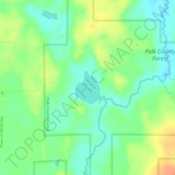
Naam: Topografische kaart Mackie Lake, hoogte, reliëf.
Gemiddelde hoogte: 363 m
Minimale hoogte: 346 m
Maximale hoogte: 388 m
Andere topografische kaarten
Klik op een kaart om zijn topografie, zijn hoogte en zijn reliëf te bekijken.
Wisconsin Rapids
USA > Wisconsin > Wisconsin Rapids
Wisconsin Rapids, Wood County, Wisconsin, USA
Gemiddelde hoogte: 312 m
Harvey Creek
Harvey Creek, Buffalo County, Wisconsin, 54755, USA
Gemiddelde hoogte: 278 m
Empire Praries State Natural Area - Hagen Prarie Unit
Empire Praries State Natural Area - Hagen Prarie Unit, Town of Lowville, Columbia County, Wisconsin, 53960, USA
Gemiddelde hoogte: 297 m
Carroll Lake
Carroll Lake, Lindgren Road, Wills, Town of Hughes, Bayfield County, Wisconsin, USA
Gemiddelde hoogte: 366 m
Silver Creek
Silver Creek, Town of Almon, Shawano County, Wisconsin, 54416, USA
Gemiddelde hoogte: 371 m
Winnebago County
Town of Wolf River, Winnebago County, Wisconsin, USA
Gemiddelde hoogte: 231 m
Manitoba Park
Manitoba Park, 2941, Jackson Park, Milwaukee, Milwaukee County, Wisconsin, 53219, USA
Gemiddelde hoogte: 216 m
Turtle River
Turtle River, Town of Winchester, Vilas County, Wisconsin, 54577, USA
Gemiddelde hoogte: 502 m
Madeline Island
Madeline Island, Ashland County, Wisconsin, 54580, USA
Gemiddelde hoogte: 187 m
Mosquito Creek
Mosquito Creek, Town of Fremont, Waupaca County, Wisconsin, USA
Gemiddelde hoogte: 232 m
Pigeon River
Pigeon River, Town of Larrabee, Waupaca County, Wisconsin, 54929, USA
Gemiddelde hoogte: 259 m
Crystal River
Crystal River, Town of Lind, Waupaca County, Wisconsin, 54981, USA
Gemiddelde hoogte: 266 m
Mackay Creek
Mackay Creek, Town of Crystal, Washburn County, Wisconsin, 54802, USA
Gemiddelde hoogte: 347 m
Dorothy Lake
USA > Wisconsin > Lake Tomahawk
Dorothy Lake, Dorothy Lake Road, Lake Tomahawk, Town of Lake Tomahawk, Oneida County, Wisconsin, 54539, USA
Gemiddelde hoogte: 498 m
Clearwater Lake
USA > Wisconsin > Clearwater Lake
Clearwater Lake, Town of Three Lakes, Oneida County, Wisconsin, USA
Gemiddelde hoogte: 500 m
Russet Lake
Russet Lake, Lone Pine Drive, Town of Presque Isle, Vilas County, Wisconsin, USA
Gemiddelde hoogte: 516 m
Muskrat Lake
Muskrat Lake, Silver Lake Road, Alpha, Town of Wood River, Burnett County, Wisconsin, 54840, USA
Gemiddelde hoogte: 294 m
Basswood Lake
Basswood Lake, 105th Avenue, Ubet, Town of Garfield, Polk County, Wisconsin, 54001, USA
Gemiddelde hoogte: 333 m
Pelican Lake
USA > Wisconsin > Pelican Lake
Pelican Lake, Town of Schoepke, Oneida County, Wisconsin, 54463, USA
Gemiddelde hoogte: 487 m
Necedah National Wildlife Refuge
Necedah National Wildlife Refuge, Town of Necedah, Juneau County, Wisconsin, USA
Gemiddelde hoogte: 287 m
Madeline Lake
Madeline Lake, Fischer Landing Road, Town of Woodruff, Oneida County, Wisconsin, 54568, USA
Gemiddelde hoogte: 495 m
Farrington Creek
Farrington Creek, Buffalo County, Wisconsin, USA
Gemiddelde hoogte: 257 m
Fond Du Lac River
Fond Du Lac River, Fond du Lac County, Wisconsin, 54935, USA
Gemiddelde hoogte: 230 m
Story Hill
Story Hill, Milwaukee, Milwaukee County, Wisconsin, USA
Gemiddelde hoogte: 202 m
Shell Lake
USA > Wisconsin > Shell Lake
Shell Lake, Washburn County, Wisconsin, USA
Gemiddelde hoogte: 377 m
McCabe Lake
McCabe Lake, Spider Lake Road, Town of Pine Lake, Oneida County, Wisconsin, 54501, USA
Gemiddelde hoogte: 487 m
Little Turtle River
Little Turtle River, Town of Mercer, Iron County, Wisconsin, USA
Gemiddelde hoogte: 488 m
Grand Chute
USA > Wisconsin > Grand Chute
Grand Chute, Town of Grand Chute, Outagamie County, Wisconsin, 54913, USA
Gemiddelde hoogte: 247 m
Saint Joseph Lake
Saint Joseph Lake, St Joseph Church Road, Town of Menominee, Menominee County, Wisconsin, USA
Gemiddelde hoogte: 274 m