
Topografische kaart Bullskin Township
Interactieve kaart
Klik op de kaart om de hoogte weer te geven.
Bullskin Township
Bullskin Township is in northeastern Fayette County, bordered to the north by Westmoreland County. The eastern border of the township follows the crest of Chestnut Ridge, reaching elevations of 2,340 feet (710 m) above sea level. According to the United States Census Bureau, the township has a total area of 43.64 square miles (113.02 km2), of which 43.53 square miles (112.75 km2) is land and 0.11 square miles (0.272 km2), or 0.24%, is water.
Over deze kaart
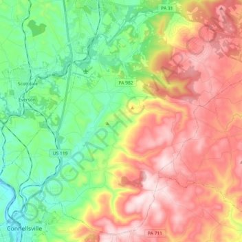
Naam: Topografische kaart Bullskin Township, hoogte, reliëf.
Gemiddelde hoogte: 458 m
Minimale hoogte: 258 m
Maximale hoogte: 713 m
Andere topografische kaarten
Klik op een kaart om zijn topografie, zijn hoogte en zijn reliëf te bekijken.