
Topografische kaart Davison Street
Interactieve kaart
Klik op de kaart om de hoogte weer te geven.
Over deze kaart
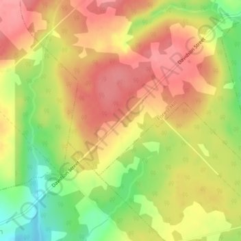
Naam: Topografische kaart Davison Street, hoogte, reliëf.
Gemiddelde hoogte: 195 m
Minimale hoogte: 142 m
Maximale hoogte: 229 m
Andere topografische kaarten
Klik op een kaart om zijn topografie, zijn hoogte en zijn reliëf te bekijken.
Gaspereau Mountain
Canada > Nova Scotia > Municipality of the County of Kings > Forest Hill
Gaspereau Mountain, Forest Hill, Municipality of the County of Kings, Kings County, Nova Scotia, B4P 2R1, Canada
Gemiddelde hoogte: 185 m