
Topografische kaart Trail
Interactieve kaart
Klik op de kaart om de hoogte weer te geven.
Over deze kaart
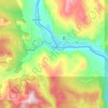
Naam: Topografische kaart Trail, hoogte, reliëf.
Gemiddelde hoogte: 888 m
Minimale hoogte: 395 m
Maximale hoogte: 1.637 m
Summer climate in Trail is generally hot and dry with moderately cool nights. Temperatures often exceed 35 °C (95 °F) during summer afternoons, average 29 °C (84 °F). Thunderstorms are common during the late-Spring and Summer season, often moving into the valley from the south. The fall months bring dense river fog, especially overnight and in the morning, as a cold air inversion lingers above the relatively warm river surface. Winters are mild to cold with periods of moderate snowfall. Nearby villages such as Warfield, Fruitvale and especially Rossland receive greater amounts of snow due to higher elevation.
Andere topografische kaarten
Klik op een kaart om zijn topografie, zijn hoogte en zijn reliëf te bekijken.
Stump Lake
Canada > British Columbia > Regional District of Kootenay Boundary > Area E (Beaverdell/West Boundary)
Stump Lake, Area E (Beaverdell/West Boundary), Regional District of Kootenay Boundary, British Columbia, Canada
Gemiddelde hoogte: 1.321 m
Grand Forks
Canada > British Columbia > Regional District of Kootenay Boundary
Grand Forks, Regional District of Kootenay Boundary, British Columbia, Canada
Gemiddelde hoogte: 586 m
Rossland
Canada > British Columbia > Regional District of Kootenay Boundary
Rossland, Regional District of Kootenay Boundary, British Columbia, V0G 1Y0, Canada
Gemiddelde hoogte: 1.128 m
Regional District of Kootenay Boundary
Canada > British Columbia > Regional District of Kootenay Boundary
Regional District of Kootenay Boundary, British Columbia, Canada
Gemiddelde hoogte: 1.215 m