
Topografische kaart Gilly
Interactieve kaart
Klik op de kaart om de hoogte weer te geven.
Over deze kaart
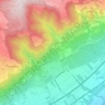
Naam: Topografische kaart Gilly, hoogte, reliëf.
Locatie: Gilly, District de Nyon, Waadland, 1182, Zwitserland (46.44494 6.27906 46.48035 6.32473)
Gemiddelde hoogte: 604 m
Minimale hoogte: 380 m
Maximale hoogte: 898 m
Andere topografische kaarten
Klik op een kaart om zijn topografie, zijn hoogte en zijn reliëf te bekijken.
Rolle
Zwitserland > Waadland > District de Nyon
Rolle, District de Nyon, Waadland, 1180, Zwitserland
Gemiddelde hoogte: 394 m
Longirod
Zwitserland > Waadland > District de Nyon > Longirod
Longirod, District de Nyon, Waadland, 1261, Zwitserland
Gemiddelde hoogte: 985 m
La Dôle
Zwitserland > Waadland > District de Nyon > Gingins
La Dôle, Gingins, Grand Genève, District de Nyon, Waadland, 1276, Zwitserland
Gemiddelde hoogte: 1.435 m
Genolier
Zwitserland > Waadland > District de Nyon
Genolier, District de Nyon, Waadland, 1272, Zwitserland
Gemiddelde hoogte: 564 m
Gingins
Zwitserland > Waadland > District de Nyon
Gingins, District de Nyon, Waadland, 1276, Zwitserland
Gemiddelde hoogte: 773 m
Nyon
Zwitserland > Waadland > District de Nyon
Nyon, District de Nyon, Waadland, 1260, Zwitserland
Gemiddelde hoogte: 404 m