
Topografische kaart Bengaluru
Interactieve kaart
Klik op de kaart om de hoogte weer te geven.
Over deze kaart
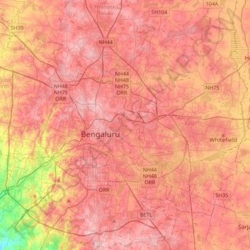
Naam: Topografische kaart Bengaluru, hoogte, reliëf.
Gemiddelde hoogte: 881 m
Minimale hoogte: 722 m
Maximale hoogte: 965 m
Bangalore (/bæŋɡəˈlɔːr/), officially Bengaluru (Kannada pronunciation: [ˈbeŋgɐɭuːɾu] (listen)), is the capital and largest city of the Indian state of Karnataka. It has a population of more than 8 million and a metropolitan population of around 11 million, making it the third most populous city and fifth most populous urban agglomeration in India, as well as the largest city in South India, and the 27th largest city in the world. Located on the Deccan Plateau, at a height of over 900 m (3,000 ft) above sea level, Bangalore has a pleasant climate throughout the year, with its parks and green spaces earning it the reputation as the "Garden City" of India. Its elevation is the highest among the major cities of India. An aerospace and electronics hub since the 1960s, Bangalore is widely regarded as the "Silicon Valley of India" because of its role as the nation's leading information technology (IT) exporter. In the Ease of Living Index 2020 (published by the Ministry of Housing and Urban Affairs), it was ranked the most livable Indian city with a population of over a million. It also ranks among the highest Indian cities in terms of global livability rankings as well.
Andere topografische kaarten
Klik op een kaart om zijn topografie, zijn hoogte en zijn reliëf te bekijken.
Chikkabidarakallu
India > Karnataka > Bangalore North
Chikkabidarakallu, Bangalore North, Bengaluru Urban, Karnataka, 560073, India
Gemiddelde hoogte: 877 m
Sampangiram Nagar Ward
India > Karnataka > Bangalore North > Bengaluru
Sampangiram Nagar Ward, East Zone, Bengaluru, Bangalore North, Bengaluru Urban District, Karnataka, India, Cubbon Park
Gemiddelde hoogte: 917 m
Ullal Lake
India > Karnataka > Bangalore North > Bengaluru
Ullal Lake, Ullalu Upanagara, Ullalu, Rajarajeshwari Nagar Zone, Bengaluru, Bangalore North, Bangalore Urban, Karnataka, India
Gemiddelde hoogte: 843 m
Vidyaranyapura
India > Karnataka > Bangalore North > Bengaluru
Vidyaranyapura, Yelahanka Zone, Bengaluru, Bangalore North, Bangalore Urban, Karnataka, India
Gemiddelde hoogte: 920 m
HBR Layout
India > Karnataka > Bangalore North > Bengaluru
HBR Layout, East Zone, Bengaluru, Bangalore North, Bangalore Urban, Karnataka, 560045, India
Gemiddelde hoogte: 893 m
Kammanahalli
India > Karnataka > Bangalore North > Bengaluru
Kammanahalli, East Zone, Bengaluru, Bangalore North, Bangalore Urban, Karnataka, 560033, India
Gemiddelde hoogte: 908 m
Bagaluru
India > Karnataka > Bangalore North > Bagaluru
Bagaluru, Bangalore North, Bangalore Urban, Karnataka, 562149, India
Gemiddelde hoogte: 899 m
Kalenahalli
India > Karnataka > Bangalore North > Muthkuru > Kalenahalli
Kalenahalli, Muthkuru, Bangalore North, Bangalore Urban, Karnataka, 560089, India
Gemiddelde hoogte: 877 m