
Doe een donatie
Rust jezelf uit voor je volgende avontuur:
Als Amazon-partner verdient deze site een commissie op in aanmerking komende aankopen, zonder extra kosten voor jou.
Topografische kaart Tadmur
Klik op de kaart om de hoogte weer te geven.
Doe een donatie
Rust jezelf uit voor je volgende avontuur:
Als Amazon-partner verdient deze site een commissie op in aanmerking komende aankopen, zonder extra kosten voor jou.
Tadmur
With the elevation of Palmyra to a colonia around 213–216, the city ceased being subject to Roman provincial governors and taxes. Palmyra incorporated Roman institutions into its system while keeping many of its former ones. The council remained, and the strategos designated one of two annually-elected magistrates. This duumviri implemented the new colonial constitution, replacing the archons. Palmyra's political scene changed with the rise of Odaenathus and his family; an inscription dated to 251 describes Odaenathus' son Hairan I as "Ras" (lord) of Palmyra (exarch in the Greek section of the inscription) and another inscription dated to 252 describes Odaenathus with the same title. Odaenathus was probably elected by the council as exarch, which was an unusual title in the Roman empire and was not part of the traditional Palmyrene governance institutions. Whether Odaenathus' title indicated a military or a priestly position is unknown, but the military role is more likely. By 257 Odaenathus was known as a consularis, possibly the legatus of the province of Phoenice. In 258 Odaenathus began extending his political influence, taking advantage of regional instability caused by Sasanian aggression; this culminated in the Battle of Edessa, Odaenathus' royal elevation and mobilization of troops, which made Palmyra a kingdom.
Doe een donatie
Rust jezelf uit voor je volgende avontuur:
Als Amazon-partner verdient deze site een commissie op in aanmerking komende aankopen, zonder extra kosten voor jou.
Over deze kaart
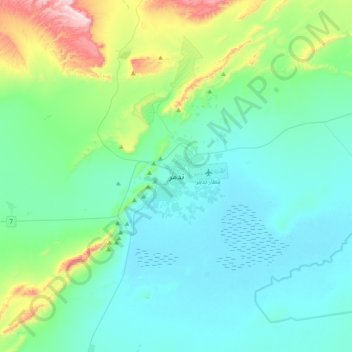
Naam: Topografische kaart Tadmur, hoogte, reliëf.
Gemiddelde hoogte: 499 m
Minimale hoogte: 374 m
Maximale hoogte: 1.071 m
Doe een donatie
Rust jezelf uit voor je volgende avontuur:
Als Amazon-partner verdient deze site een commissie op in aanmerking komende aankopen, zonder extra kosten voor jou.
Andere topografische kaarten
Klik op een kaart om zijn topografie, zijn hoogte en zijn reliëf te bekijken.
Doe een donatie
Rust jezelf uit voor je volgende avontuur:
Als Amazon-partner verdient deze site een commissie op in aanmerking komende aankopen, zonder extra kosten voor jou.