
Topografische kaart Twin Brooks
Interactieve kaart
Klik op de kaart om de hoogte weer te geven.
Over deze kaart
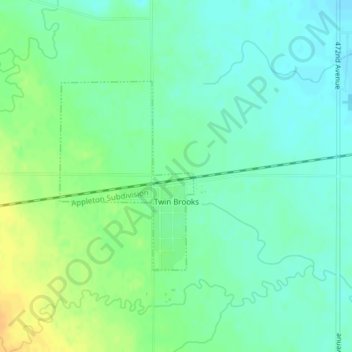
Naam: Topografische kaart Twin Brooks, hoogte, reliëf.
Locatie: Twin Brooks, Grant County, South Dakota, United States (45.20054 -96.79223 45.21505 -96.77761)
Gemiddelde hoogte: 385 m
Minimale hoogte: 374 m
Maximale hoogte: 402 m
Andere topografische kaarten
Klik op een kaart om zijn topografie, zijn hoogte en zijn reliëf te bekijken.
La Bolt
United States > South Dakota > Grant County
La Bolt, Grant County, South Dakota, United States
Gemiddelde hoogte: 418 m
Big Stone City
United States > South Dakota > Grant County
Big Stone City, Grant County, South Dakota, United States
Gemiddelde hoogte: 314 m
Strandburg
United States > South Dakota > Grant County
Strandburg, Grant County, South Dakota, United States
Gemiddelde hoogte: 512 m
Stockholm
United States > South Dakota > Grant County
Stockholm, Grant County, South Dakota, United States
Gemiddelde hoogte: 503 m
Milbank
United States > South Dakota > Grant County
Milbank, Grant County, South Dakota, United States
Gemiddelde hoogte: 350 m
Revillo
United States > South Dakota > Grant County
Revillo, Grant County, South Dakota, United States
Gemiddelde hoogte: 369 m
Marvin
United States > South Dakota > Grant County
Marvin, Grant County, South Dakota, United States
Gemiddelde hoogte: 501 m