
Topografische kaart Kapuskasing
Interactieve kaart
Klik op de kaart om de hoogte weer te geven.
Over deze kaart
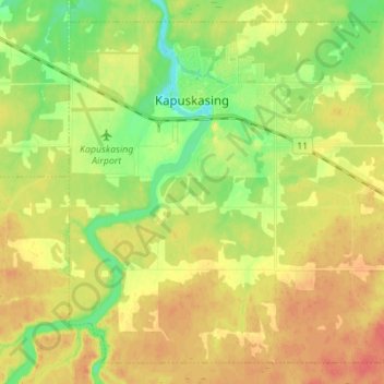
Naam: Topografische kaart Kapuskasing, hoogte, reliëf.
Gemiddelde hoogte: 227 m
Minimale hoogte: 202 m
Maximale hoogte: 249 m
Kapuskasing lies in the heart of the Great Clay Belt. The topography of the region is very flat, dotted with numerous small lakes and muskeg bogs. Also in the heart of Canada's boreal forest, the region is drained by rivers running north to James Bay. The district is heavily forested, mostly by thick stands of black spruce that have commercial value as pulpwood.
Andere topografische kaarten
Klik op een kaart om zijn topografie, zijn hoogte en zijn reliëf te bekijken.
Moosonee
Canada > Ontario > Cochrane District
Moosonee, Cochrane District, Northeastern Ontario, Ontario, P0L 1Y0, Canada
Gemiddelde hoogte: 13 m
Heart Lake
Canada > Ontario > Cochrane District > Timmins
Heart Lake, Timmins, Cochrane District, Northeastern Ontario, Ontario, Canada
Gemiddelde hoogte: 294 m
Shallow River
Canada > Ontario > Cochrane District > Iroquois Falls
Shallow River, Iroquois Falls, Cochrane District, Northeastern Ontario, Ontario, Canada
Gemiddelde hoogte: 272 m
Wavell
Canada > Ontario > Cochrane District > Black River-Matheson Township
Wavell, Black River-Matheson Township, Cochrane District, Northeastern Ontario, Ontario, Canada
Gemiddelde hoogte: 304 m
Schumacher
Canada > Ontario > Cochrane District > Timmins
Schumacher, Timmins, Cochrane District, Northeastern Ontario, Ontario, P0N 1G0, Canada
Gemiddelde hoogte: 306 m
Timmins
Canada > Ontario > Cochrane District
Timmins, Cochrane District, Northeastern Ontario, Ontario, Canada
Gemiddelde hoogte: 302 m
Ramore
Canada > Ontario > Cochrane District
Ramore, Black River-Matheson Township, Cochrane District, Northeastern Ontario, Ontario, Canada
Gemiddelde hoogte: 289 m