
Topografische kaart Deddington
Interactieve kaart
Klik op de kaart om de hoogte weer te geven.
Over deze kaart
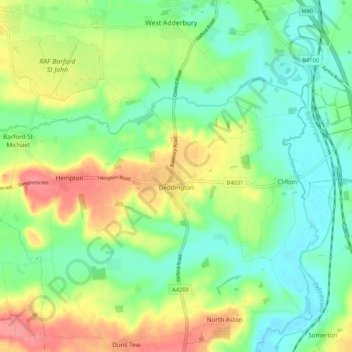
Naam: Topografische kaart Deddington, hoogte, reliëf.
Gemiddelde hoogte: 107 m
Minimale hoogte: 75 m
Maximale hoogte: 159 m
Clifton, Deddington and Hempton stand on a ridge of Jurassic ferruginous marlstone hills between the three watercourses. Clifton is about 1+1⁄2 miles (2.4 km) east of Deddington, at the eastern end of the ridge where it slopes down to the Cherwell. The ridges rises westward. Deddington is about 430 feet (130 m) above sea level. Hempton is about 1+1⁄2 miles (2.4 km) west of Deddington and about 489 feet (149 m) above sea level. The highest point of the ridge is on the western boundary of the parish, more than 490 feet (150 m) above sea level. The parish's topography is alluded to in a local rhyme:
Andere topografische kaarten
Klik op een kaart om zijn topografie, zijn hoogte en zijn reliëf te bekijken.
Ambrosden
United Kingdom > England > Oxfordshire > Cherwell District
Ambrosden, Cherwell District, Oxfordshire, England, United Kingdom
Gemiddelde hoogte: 66 m
Cottisford
United Kingdom > England > Oxfordshire > Cherwell District
Cottisford, Cherwell District, Oxfordshire, England, United Kingdom
Gemiddelde hoogte: 121 m
Launton
United Kingdom > England > Oxfordshire > Cherwell District
Launton, Cherwell District, Oxfordshire, England, United Kingdom
Gemiddelde hoogte: 73 m
Kirtlington
United Kingdom > England > Oxfordshire > Cherwell District
Kirtlington, Cherwell District, Oxfordshire, England, United Kingdom
Gemiddelde hoogte: 89 m
Bicester
United Kingdom > England > Oxfordshire > Cherwell District
Bicester, Cherwell District, Oxfordshire, England, United Kingdom
Gemiddelde hoogte: 76 m
Adderbury
United Kingdom > England > Oxfordshire > Cherwell District
Adderbury, Cherwell District, Oxfordshire, England, United Kingdom
Gemiddelde hoogte: 100 m
Banbury
United Kingdom > England > Oxfordshire > Cherwell District
Banbury, Cherwell District, Oxfordshire, England, United Kingdom
Gemiddelde hoogte: 116 m