
Topografische kaart Bresolettes
Interactieve kaart
Klik op de kaart om de hoogte weer te geven.
Over deze kaart
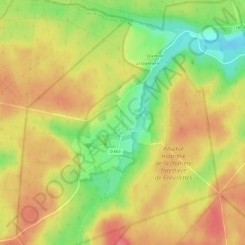
Naam: Topografische kaart Bresolettes, hoogte, reliëf.
Gemiddelde hoogte: 281 m
Minimale hoogte: 238 m
Maximale hoogte: 311 m
Andere topografische kaarten
Klik op een kaart om zijn topografie, zijn hoogte en zijn reliëf te bekijken.
Belle Perche
France > Normandie > Orne > Tourouvre au Perche
Belle Perche, Randonnai, Tourouvre au Perche, Mortagne-au-Perche, Orne, Normandie, France métropolitaine, 61190, France
Gemiddelde hoogte: 266 m
L'Etre Châtel
France > Normandie > Orne > Tourouvre au Perche
L'Etre Châtel, Autheuil, Tourouvre au Perche, Mortagne-au-Perche, Orne, Normandie, France métropolitaine, 61190, France
Gemiddelde hoogte: 225 m
Lignerolles
France > Normandie > Orne > Tourouvre au Perche
Lignerolles, Tourouvre au Perche, Mortagne-au-Perche, Orne, Normandie, France métropolitaine, 61190, France
Gemiddelde hoogte: 275 m
Autheuil
France > Normandie > Orne > Tourouvre au Perche
Autheuil, Tourouvre au Perche, Mortagne-au-Perche, Orne, Normandie, France métropolitaine, 61190, France
Gemiddelde hoogte: 222 m
La Sablonnière
France > Normandie > Orne > Tourouvre au Perche > La Sablonnière
La Sablonnière, Tourouvre, Tourouvre au Perche, Mortagne-au-Perche, Orne, Normandie, France métropolitaine, 61190, France
Gemiddelde hoogte: 257 m
La Planche
France > Normandie > Orne > Tourouvre au Perche > La Planche
La Planche, Autheuil, Tourouvre au Perche, Mortagne-au-Perche, Orne, Normandie, France métropolitaine, 61190, France
Gemiddelde hoogte: 226 m
Bubertré
France > Normandie > Orne > Tourouvre au Perche
Bubertré, Tourouvre au Perche, Mortagne-au-Perche, Orne, Normandie, France métropolitaine, 61190, France
Gemiddelde hoogte: 266 m