
Topografische kaart Hastings
Interactieve kaart
Klik op de kaart om de hoogte weer te geven.
Over deze kaart
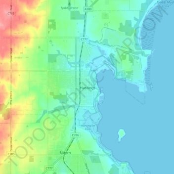
Naam: Topografische kaart Hastings, hoogte, reliëf.
Gemiddelde hoogte: 23 m
Minimale hoogte: -1 m
Maximale hoogte: 98 m
Andere topografische kaarten
Klik op een kaart om zijn topografie, zijn hoogte en zijn reliëf te bekijken.
Jack's Beach
Australia > Victoria > Hastings
Jack's Beach, Hastings, Shire of Mornington Peninsula, Victoria, 3919, Australia
Gemiddelde hoogte: 7 m
Warringine Park
Australia > Victoria > Hastings
Warringine Park, Bittern, Hastings, Shire of Mornington Peninsula, Victoria, Australia
Gemiddelde hoogte: 12 m