
Topografische kaart Smithgall Woods State Park
Interactieve kaart
Klik op de kaart om de hoogte weer te geven.
Over deze kaart
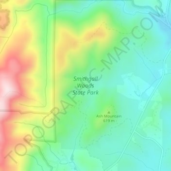
Naam: Topografische kaart Smithgall Woods State Park, hoogte, reliëf.
Gemiddelde hoogte: 612 m
Minimale hoogte: 467 m
Maximale hoogte: 891 m
Andere topografische kaarten
Klik op een kaart om zijn topografie, zijn hoogte en zijn reliëf te bekijken.
Helen
United States > Georgia > White County
Helen, White County, Georgia, 30545, United States
Gemiddelde hoogte: 488 m
Unicoi Lake
United States > Georgia > White County
Unicoi Lake, White County, Georgia, United States
Gemiddelde hoogte: 562 m
Nacoochee
United States > Georgia > White County
Nacoochee, White County, Georgia, 30545, United States
Gemiddelde hoogte: 449 m
Raven Cliff Falls
United States > Georgia > White County
Raven Cliff Falls, White County, Georgia, United States
Gemiddelde hoogte: 922 m
Cleveland
United States > Georgia > White County
Cleveland, White County, Georgia, 30528, United States
Gemiddelde hoogte: 479 m
Mossy Creek
United States > Georgia > White County
Mossy Creek, White County, Georgia, United States
Gemiddelde hoogte: 416 m
Sautee
United States > Georgia > White County
Sautee, White County, Georgia, 30571, United States
Gemiddelde hoogte: 441 m
Yonah Mountain
United States > Georgia > White County
Yonah Mountain, White County, Georgia, United States
Gemiddelde hoogte: 619 m