
Topografische kaart Distrito Bugaba
Interactieve kaart
Klik op de kaart om de hoogte weer te geven.
Over deze kaart
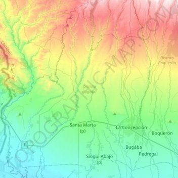
Naam: Topografische kaart Distrito Bugaba, hoogte, reliëf.
Locatie: Distrito Bugaba, Chiriquí, Panamá (8.43569 -82.83675 8.72721 -82.59150)
Gemiddelde hoogte: 446 m
Minimale hoogte: 7 m
Maximale hoogte: 1.365 m
Andere topografische kaarten
Klik op een kaart om zijn topografie, zijn hoogte en zijn reliëf te bekijken.
Siogui Abajo (p)
Panamá > Chiriquí > Distrito Bugaba > La Estrella
Siogui Abajo (p), La Estrella, Distrito Bugaba, Chiriquí, Panamá
Gemiddelde hoogte: 126 m
Bugába
Panamá > Chiriquí > Distrito Bugaba
Bugába, Distrito Bugaba, Chiriquí, Panamá
Gemiddelde hoogte: 137 m
San Isidro
Panamá > Chiriquí > Distrito Bugaba > Aserrío de Gariché
San Isidro, Aserrío de Gariché, Distrito Bugaba, Chiriquí, Panamá
Gemiddelde hoogte: 125 m
Aserrio de Gariché
Panamá > Chiriquí > Distrito Bugaba > Aserrío de Gariché
Aserrio de Gariché, Aserrío de Gariché, Distrito Bugaba, Chiriquí, Panamá
Gemiddelde hoogte: 65 m