
Topografische kaart Hospital
Interactieve kaart
Klik op de kaart om de hoogte weer te geven.
Over deze kaart
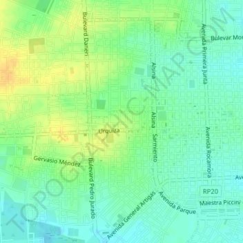
Naam: Topografische kaart Hospital, hoogte, reliëf.
Gemiddelde hoogte: 17 m
Minimale hoogte: 6 m
Maximale hoogte: 32 m
Andere topografische kaarten
Klik op een kaart om zijn topografie, zijn hoogte en zijn reliëf te bekijken.
Gualeguaychú
Argentina > Entre Ríos > Gualeguaychú
Gualeguaychú, Distrito Costa Uruguay Sur, Departamento Gualeguaychú, Entre Ríos, 2820, Argentina
Gemiddelde hoogte: 19 m
Río Gualeguaychú
Argentina > Entre Ríos > Gualeguaychú
Río Gualeguaychú, Gualeguaychú, Distrito Costa Uruguay Norte, Departamento Gualeguaychú, Entre Ríos, 2820, Argentina
Gemiddelde hoogte: 6 m
Pereyra
Argentina > Entre Ríos > Gualeguaychú
Pereyra, Gualeguaychú, Distrito Costa Uruguay Norte, Departamento Gualeguaychú, Entre Ríos, Argentina
Gemiddelde hoogte: 2 m
Laguna de los Patos
Argentina > Entre Ríos > Gualeguaychú
Laguna de los Patos, Ruta Provincial 42, Puerto, Gualeguaychú, Distrito Costa Uruguay Norte, Departamento Gualeguaychú, Entre Ríos, 2820, Argentina
Gemiddelde hoogte: 6 m
Tiro Federal
Argentina > Entre Ríos > Gualeguaychú
Tiro Federal, Gualeguaychú, Distrito Costa Uruguay Sur, Departamento Gualeguaychú, Entre Ríos, Argentina
Gemiddelde hoogte: 7 m